


 关联应用
关联应用
GNSS View
开发者: NEC Corporation
中国

版本统计
99天16小时
最新版本上线距今
1
近1年版本更新次数
2014-10-30
全球最早版本上线日期
版本记录
版本: 5.0.3
版本更新日期
2025-03-24
GNSS View
更新日志
Now support iOS 18.视频/截图
应用描述
This application enables you to see where the Quasi-Zenith Satellite System in the sky!
●What is QZSS?
Quasi-Zenith Satellite System (QZSS) is a Japanese satellite positioning system composed mainly of satellites in quasi-zenith orbits (QZO).
Satellite positioning systems use satellite signals to calculate position information. One famous example is the American Global Positioning System (GPS) and the QZSS is sometimes called the Japanese GPS.
For details, please refer to the following Website "Quasi-Zenith Satellite System".
URL : https://qzss.go.jp/en
●What is GNSS View?
GNSS View provides that iOS version application that is based on the website application "GNSS View".
This application enables you to know position of positioning satellites such as QZSS and GPS in the specified time and location.
The positioning satellites displayed in the GNSS View are not based on the satellite information directly received by the smartphone but are displayed based on the satellite arrangement calculated based on the publicly released orbit information.
●GNSS View 3 functions
【Main】
・You can move to the Position Radar screen or AR Display screen from the application startup screen.
・You can see the operating manual and privacy policy of this application via the website.
【Position Radar】
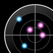
・It is provided radar view of positioning satellites such as QZSS and GPS as a sky plot at the specified time and location.
・Positioning satellites can be specified from QZSS, GPS, GLONASS, BeiDou, Galileo, SBAS.
・You can also select specified signal satellites to see on the radar.
・You can see selected satellites by setting elevation mask angle.
・You can switch east and west of satellite arrangement, turn on / off rotation, and switch on / off display of satellite number.
・It displays HDOP, VDOP, the total number of satellites and the number of each positioning satellites in the satellite arrangement displayed on the radar.
【AR Display】
・Position of positioning satellites such as QZSS and GPS on the sky from your current location is able to see through your camera at the specified time.
・In order to display satellites, it is necessary to turn on the position information of the smartphone and complete the positioning. Therefore, it may take time to display.
・Positioning satellites can be specified from QZSS, GPS, GLONASS, BeiDou, Galileo, SBAS.
・You can also select specified signal satellites to see on the radar.
・You can see selected satellites by setting elevation mask angle.
●Supported versions
・iOS 18
・iOS 17
・iOS 16
・iOS 15
・iOS 14
・iOS 13版本: 5.0.2
版本更新日期
2024-03-14
GNSS View
更新日志
Now support iOS 17.应用描述
暂无应用描述数据
版本: 5.0.1
版本更新日期
2023-04-05
GNSS View
更新日志
- Now support iOS 16.应用描述
暂无应用描述数据
版本: 5.0.0
版本更新日期
2022-04-05

GNSS View
更新日志
- Update visible satellites including QZS-1R of QZSS.
- Now support iOS 15.
视频/截图
应用描述
This application enables you to see where the Quasi-Zenith Satellite System in the sky!
●What is QZSS?
Quasi-Zenith Satellite System (QZSS) is a Japanese satellite positioning system composed mainly of satellites in quasi-zenith orbits (QZO).
Satellite positioning systems use satellite signals to calculate position information. One famous example is the American Global Positioning System (GPS) and the QZSS is sometimes called the Japanese GPS.
For details, please refer to the following Website "Quasi-Zenith Satellite System".
URL : https://qzss.go.jp/en
●What is GNSS View?
GNSS View provides that iOS version application that is based on the website application "GNSS View".
This application enables you to know position of positioning satellites such as QZSS and GPS in the specified time and location.
The positioning satellites displayed in the GNSS View are not based on the satellite information directly received by the smartphone but are displayed based on the satellite arrangement calculated based on the publicly released orbit information.
●GNSS View 3 functions
【Main】
・You can move to the Position Radar screen or AR Display screen from the application startup screen.
・You can see the operating manual and privacy policy of this application via the website.
【Position Radar】
・It is provided radar view of positioning satellites such as QZS and GPS as a sky plot at the specified time and location.
・Positioning satellites can be specified from QZSS, GPS, GLONASS, BeiDou, Galileo, SBAS.
・You can also select specified signal satellites to see on the radar.
・You can see selected satellites by setting elevation mask angle.
・You can switch east and west of satellite arrangement, turn on / off rotation, and switch on / off display of satellite number.
・It displays HDOP, VDOP, the total number of satellites and the number of each positioning satellites in the satellite arrangement displayed on the radar.
【AR Display】
・Position of positioning satellites such as QZSS and GPS on the sky from your current location is able to see through your android camera at the specified time.
・In order to display satellites, it is necessary to turn on the position information of the smartphone and complete the positioning. Therefore, it may take time to display.
・Positioning satellites can be specified from QZSS, GPS, GLONASS, BeiDou, Galileo, SBAS.
・You can also select specified signal satellites to see on the radar.
・You can see selected satellites by setting elevation mask angle.
●Supported versions
・iOS 11
・iOS 12
・iOS 13
・iOS 14
・iOS 15
版本: 4.1.0
版本更新日期
2020-03-25

GNSS View
更新日志
Now support iOS 13.视频/截图
应用描述
This application enables you to see where the Quasi-Zenith Satellite System in the sky!
●What is QZSS?
Quasi-Zenith Satellite System (QZSS) is a Japanese satellite positioning system composed mainly of satellites in quasi-zenith orbits (QZO).
Satellite positioning systems use satellite signals to calculate position information. One famous example is the American Global Positioning System (GPS) and the QZSS is sometimes called the Japanese GPS.
For details, please refer to the following Website "Quasi-Zenith Satellite System".
URL : https://qzss.go.jp/en
●What is GNSS View?
GNSS View provides that android version application that is based on the website application "GNSS View". This application is optimized for the 32bit.
This application enables you to know position of positioning satellites such as QZSS and GPS in the specified time and location.
The positioning satellites displayed in the GNSS View are not based on the satellite information directly received by the smartphone but are displayed based on the satellite arrangement calculated based on the publicly released orbit information.
●GNSSView 3 functions
【Main】
・You can move to the Position Radar screen or AR Display screen from the application startup screen.
・You can see the operating manual and privacy policy of this application via the website.
【Position Radar】
・It is provided radar view of positioning satellites such as QZS and GPS as a sky plot at the specified time and location.
・Positioning satellites can be specified from QZSS, GPS, GLONASS, BeiDou, Galileo, SBAS.
・You can also select specified signal satellites to see on the radar.
・You can see selected satellites by setting elevation mask angle.
・You can switch east and west of satellite arrangement, turn on / off rotation, and switch on / off display of satellite number.
・It displays HDOP, VDOP, the total number of satellites and the number of each positioning satellites in the satellite arrangement displayed on the radar.
【AR Display】
・Position of positioning satellites such as QZSS and GPS on the sky from your current location is able to see through your android camera at the specified time.
・In order to display satellites, it is necessary to turn on the position information of the smartphone and complete the positioning. Therefore, it may take time to display.
・Positioning satellites can be specified from QZSS, GPS, GLONASS, BeiDou, Galileo, SBAS.
・You can also select specified signal satellites to see on the radar.
・You can see selected satellites by setting elevation mask angle.
●Supported versions
・iOS 8.0
・iOS 8.1
・iOS 8.2
・iOS 8.3
・iOS 8.4
・iOS 9.0
・iOS 9.1
・iOS 9.2
・iOS 9.3
・iOS 10.0
・iOS 10.1
・iOS 10.2
・iOS 10.3
・iOS 11.0
・iOS 11.1
・iOS 11.2
・iOS 12.0
・iOS 12.1
・iOS 12.2
・iOS 12.3
・iOS 12.4
・iOS 13.0
・iOS 13.1
・iOS 13.2
・iOS 13.3
版本: 4.0.2
版本更新日期
2019-08-23

GNSS View
更新日志
Coped with Web API access method change (SSL) of quasi-zenith satellite system (QZSS).视频/截图
应用描述
This application enables you to see where the Quasi-Zenith Satellite System in the sky!
●What is QZSS?
Quasi-Zenith Satellite System (QZSS) is a Japanese satellite positioning system composed mainly of satellites in quasi-zenith orbits (QZO).
Satellite positioning systems use satellite signals to calculate position information. One famous example is the American Global Positioning System (GPS) and the QZSS is sometimes called the Japanese GPS.
For details, please refer to the following Website "Quasi-Zenith Satellite System".
URL : https://qzss.go.jp/en
●What is GNSS View?
GNSS View provides that android version application that is based on the website application "GNSS View". This application is optimized for the 32bit.
This application enables you to know position of positioning satellites such as QZSS and GPS in the specified time and location.
The positioning satellites displayed in the GNSS View are not based on the satellite information directly received by the smartphone but are displayed based on the satellite arrangement calculated based on the publicly released orbit information.
●GNSSView 3 functions
【Main】
・You can move to the Position Radar screen or AR Display screen from the application startup screen.
・You can see the operating manual and privacy policy of this application via the website.
【Position Radar】
・It is provided radar view of positioning satellites such as QZS and GPS as a sky plot at the specified time and location.
・Positioning satellites can be specified from QZSS, GPS, GLONASS, BeiDou, Galileo, SBAS.
・You can also select specified signal satellites to see on the radar.
・You can see selected satellites by setting elevation mask angle.
・You can switch east and west of satellite arrangement, turn on / off rotation, and switch on / off display of satellite number.
・It displays HDOP, VDOP, the total number of satellites and the number of each positioning satellites in the satellite arrangement displayed on the radar.
【AR Display】
・Position of positioning satellites such as QZSS and GPS on the sky from your current location is able to see through your android camera at the specified time.
・In order to display satellites, it is necessary to turn on the position information of the smartphone and complete the positioning. Therefore, it may take time to display.
・Positioning satellites can be specified from QZSS, GPS, GLONASS, BeiDou, Galileo, SBAS.
・You can also select specified signal satellites to see on the radar.
・You can see selected satellites by setting elevation mask angle.
●Supported versions
・iOS 8.0
・iOS 8.1
・iOS 8.2
・iOS 8.3
・iOS 8.4
・iOS 9.0
・iOS 9.1
・iOS 9.2
・iOS 9.3
・iOS 10.0
・iOS 10.1
・iOS 10.2
・iOS 10.3
・iOS 11.0
・iOS 11.1
・iOS 11.2
・iOS 12.0
・iOS 12.1
・iOS 12.2
・iOS 12.3
・iOS 12.4版本: 4.0.1
版本更新日期
2019-03-12

GNSS View
更新日志
- Bug fix.视频/截图
应用描述
This application enables you to see where the Quasi-Zenith Satellite System (four-QZS constellation) in the sky!
●What is QZSS?
Quasi-Zenith Satellite System (QZSS) is a Japanese satellite positioning system composed mainly of satellites in quasi-zenith orbits (QZO).
Satellite positioning systems use satellite signals to calculate position information. One famous example is the American Global Positioning System (GPS) and the QZSS is sometimes called the Japanese GPS.
For details, please refer to the following Website "Quasi-Zenith Satellite System".
URL : http://qzss.go.jp/en
●What is GNSS View?
GNSS View provides that iPhone version application that is based on the website application "GNSS View".
This application enables you to know position of positioning satellites such as QZSS and GPS in the specified time and location.
In addition to the first QZS "Michibiki", you can also see the four-satellite-constellation QZSS which will be operated from FY2018.
The positioning satellites displayed in the GNSS View are not based on the satellite information directly received by the smartphone but are displayed based on the satellite arrangement calculated based on the publicly released orbit information.
●GNSSView 3 functions
【Main】
・You can move to the Position Radar screen or AR Display screen from the application startup screen.
【Position Radar】
・It is provided radar view of positioning satellites such as QZS and GPS as a sky plot at the specified time and location.
・Positioning satellites can be specified from QZSS, GPS, GLONASS, BeiDou, Galileo, SBAS.
・You can also select specified signal satellites to see on the radar.
・You can see selected satellites by setting elevation mask angle.
・You can switch east and west of satellite arrangement, turn on / off rotation, and switch on / off display of satellite number.
・It displays HDOP, VDOP, the total number of satellites and the number of each positioning satellites in the satellite arrangement displayed on the radar.
【AR Display】
・Position of positioning satellites such as QZSS and GPS on the sky from your current location is able to see through your camera at the specified time.
・In order to display satellites, it is necessary to turn on the position information of the smartphone and complete the positioning. Therefore, it may take time to display.
・Positioning satellites can be specified from QZSS, GPS, GLONASS, BeiDou, Galileo, SBAS.
・You can also select specified signal satellites to see on the radar.
・You can see selected satellites by setting elevation mask angle.
●Supported versions
・iOS 8.0
・iOS 8.1
・iOS 8.2
・iOS 8.3
・iOS 8.4
・iOS 9.0
・iOS 9.1
・iOS 9.2
・iOS 9.3
・iOS 10.0
・iOS 10.1
・iOS 10.2
・iOS 10.3
・iOS 11.0
・iOS 11.1
・iOS 11.2
・iOS 12.0
・iOS 12.1版本: 4.0.0
版本更新日期
2019-03-07

GNSS View
更新日志
Fixed the QZSS of Select Satellite with the launch of the Quasi-Zenith Satellite System (QZSS) service.视频/截图
应用描述
This application enables you to see where the Quasi-Zenith Satellite System (four-QZS constellation) in the sky!
●What is QZSS?
Quasi-Zenith Satellite System (QZSS) is a Japanese satellite positioning system composed mainly of satellites in quasi-zenith orbits (QZO).
Satellite positioning systems use satellite signals to calculate position information. One famous example is the American Global Positioning System (GPS) and the QZSS is sometimes called the Japanese GPS.
For details, please refer to the following Website "Quasi-Zenith Satellite System".
URL : http://qzss.go.jp/en
●What is GNSS View?
GNSS View provides that iPhone version application that is based on the website application "GNSS View".
This application enables you to know position of positioning satellites such as QZSS and GPS in the specified time and location.
In addition to the first QZS "Michibiki", you can also see the four-satellite-constellation QZSS which will be operated from FY2018.
The positioning satellites displayed in the GNSS View are not based on the satellite information directly received by the smartphone but are displayed based on the satellite arrangement calculated based on the publicly released orbit information.
●GNSSView 3 functions
【Main】
・You can move to the Position Radar screen or AR Display screen from the application startup screen.
【Position Radar】
・It is provided radar view of positioning satellites such as QZS and GPS as a sky plot at the specified time and location.
・Positioning satellites can be specified from QZSS, GPS, GLONASS, BeiDou, Galileo, SBAS.
・You can also select specified signal satellites to see on the radar.
・You can see selected satellites by setting elevation mask angle.
・You can switch east and west of satellite arrangement, turn on / off rotation, and switch on / off display of satellite number.
・It displays HDOP, VDOP, the total number of satellites and the number of each positioning satellites in the satellite arrangement displayed on the radar.
【AR Display】
・Position of positioning satellites such as QZSS and GPS on the sky from your current location is able to see through your camera at the specified time.
・In order to display satellites, it is necessary to turn on the position information of the smartphone and complete the positioning. Therefore, it may take time to display.
・Positioning satellites can be specified from QZSS, GPS, GLONASS, BeiDou, Galileo, SBAS.
・You can also select specified signal satellites to see on the radar.
・You can see selected satellites by setting elevation mask angle.
●Supported versions
・iOS 8.0
・iOS 8.1
・iOS 8.2
・iOS 8.3
・iOS 8.4
・iOS 9.0
・iOS 9.1
・iOS 9.2
・iOS 9.3
・iOS 10.0
・iOS 10.1
・iOS 10.2
・iOS 10.3
・iOS 11.0
・iOS 11.1
・iOS 11.2
・iOS 12.0
・iOS 12.1版本: 3.1.1
版本更新日期
2018-02-27
GNSS View
更新日志
- Bug fix.
- Now support iOS 11.2.应用描述
暂无应用描述数据
版本: 3.1.0
版本更新日期
2017-06-12
GNSS View
更新日志
- Bug fix.应用描述
暂无应用描述数据


微信公众号

七麦数据公众号

七麦研究院公众号
APP下载
- IOS
- Android

@2014-2022 qimai.cn,北京七麦科技股份有限公司 All Rights Reserved. 京ICP备14049953号
 京公网安备 11010502041000号


